Watchlist
Our city and its surrounds are always evolving, and on this page you’ll find details of some of the bigger developments in prospect. These are plans where the scale or impact on the wider area means they are likely to affect life in St Albans. Our Watchlist aims to give an overview of the prospective scale of change ahead. How might our city look, and how might it function, a decade from now?
New Local Plan – site allocations
The draft Local Plan 2041 has been in preparation for several years and is expected to be adopted in March 2026. The Civic Society’s Local Plan Regulation 18 consultation responses were submitted in 2023. See our City matters page for more on this. We routinely monitor planning applications for compliance with the draft Local Plan and submit comments as and when appropriate.
The draft Local Plan includes site allocations. These are areas of land identified as meeting the Government’s policy test of having a ‘reasonable prospect’ of supporting housing developments that will be delivered at some point before 2041. A total of 98 residential sites are identified and categorised by size: broad locations of over 500 homes; broad locations of over 250 homes; large sites of over 100 homes, and so forth making up a housing total of 10,808. Hemel Garden Communities, West Redbourn and Woollam Park, outlined below, cover six of the larger areas identified as sites in the draft Local Plan.
Hemel Garden Communities and West Redbourn – 4845 homes
The Hemel Garden Communities project is a partnership programme involving Dacorum Borough Council, St Albans City and District Council, Hertfordshire County Council, Hertfordshire Futures and Hertfordshire Innovation Quarter together with The Crown Estate and other key landowners. It aims to transform Hemel Hempstead and also “create attractive and sustainable new neighbourhoods and communities to the north and east of Hemel Hempstead, through the delivery of around 11,000 new homes and up to 8,000 new jobs by 2050”. The project is integrated into the draft St Albans Local Plan (Policy LG2, Support for the Transformation of Hemel Hempstead). The land area extends into parts of Redbourn and Verulam Ward in the St Albans district.
Separately the draft Local Plan identifies an additional site for 545 homes to the west of Redbourn, adjacent to and more or less adjoining the North Hemel Hempstead broad location
The North and East Hemel site locations in the draft St Albans Local Plan cover 4,300 homes across four broad locations.
Bloor Homes and Pigeon are developing proposals for the North Hemel Hempstead broad location, which is largely in the Redbourn district of St Albans.
The three broad locations called East Hemel Hempstead (North, Central, and South) in the draft St Albans Local Plan are covered by planning application 5/2025/1964 which was submitted on 4 December 2025 and is summarised here.
The application crosses St Albans City and District Council and Dacorum Borough Council’s areas and each will assess the part of the application that falls within their administrative boundary.
Woollam Park
Off the Harpenden Road, stretching north from St Albans Girls School on Sandridgebury Lane and taking in part of the Woollam Playing Fields is a planned development of 1000 family homes. The scheme extends east across to the Midlands Mainline railway and south to the Valley Road industrial estate. It includes some affordable housing, new primary school provision and some community infrastructure but will lean on St Albans as its main commuting, shopping and services centre.
This is a large-scale proposed development on Green Belt land which has been attracting a lot of public comment. It is included as a site allocation in the emerging Local Plan. The developer has published a summary website with links to some of the planning application documents. The full set is on the planning portal under application reference 5/2024/2271.
As with other developments of this size, design and infrastructure details will be of paramount importance. The residential element of the plans has been submitted for outline approval and has not yet been determined. The Civic Society will continue to monitor the application.
Land behind 112-156B Harpenden Road
Adjacent to and west of the proposed Woollam Park development is an area of land acquired by Cala Homes for a proposed development of 124 homes with 40% of them to be categorised as affordable.
The application was approved on 1 September 2025 under planning application reference 5/2024/1284 subject to a number of conditions. These include visual amenity, with checks on the materials to be used in the external surfaces and the external reveals of the windows and doors; the provision, retention and maintenance of footways and active travel routes; and consideration of welfare issues for the badgers active in the area.
City centre/ Argos site
Developer Denton Homes has submitted plans for the development of the former city centre Argos building, which has been empty for some time. The site address is 5 Spencer Street and it takes in the rear boundaries of 25-37 Market Place. The application reference is 5/2025/1757.
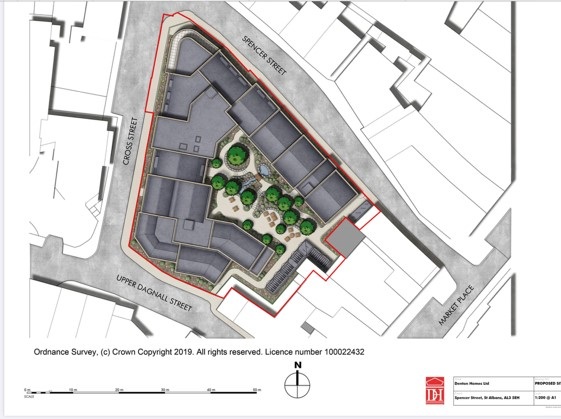
During the preparation stage the developers worked with the St Albans City and District Council team, including two meetings with planners and one with councillors, with amendments to the design after each meeting and there was also engagement with local residents. The plans are for 47 apartments, as well as cycle parking, refuse storage, and hard and soft landscaping. Consistent with other recent town centre developments and provisions in the draft Local Plan, there will be no parking provision for residents.
The existing commercial building will be demolished as part of the works and our view is that it is of no architectural merit and that the developers have proposed a reasonable and city centre development with good pedestrian access and a central light-admitting landscaped courtyard. The submission includes a detailed heritage statement with clear illustrations and an outline of the discussion and review points that have made the plans suitable for this part of the city conservation area.
City centre/ Catherine Street retirement community
The Coupers Garage in Catherine Street is no more, and in its place we will see a new retirement community of 48 homes. The developer, McCarthy Stone, met with stakeholders as part of its community engagement activity. The planning application reference is 5/2024/1007.
City centre/ Havana building
50 Victoria Street, a converted Baptist church which houses the Havana night club, is on the market with a plan for conversion into 60 studio, one- and two-bed flats. Again, it is thought there will be no parking for residents.

SEGRO Logistics Park Radlett
Sandwiched between the A414 (North Orbital) to the north; M25 to the south; the Bricket Wood, How Wood and Park Street section of the Abbey Line to the west; and the Midland Mainline to the east, this rail and road freight interchange will have 335,000 sq m of distribution units in use 24/7. An estimated 10,000 additional HGVs a day will use local roads to access the logistics park. The plan includes a rail interconnect and sidings, landscaping and changes at the Park Street roundabout to help with traffic throughput.
The low resolution image above gives a broad picture of the location and there’s greater detail on the developer’s website. Known locally by the slightly misleadingly named Strategic Rail Freight Interchange project, the development is on Green Belt land and will predominantly generate road traffic. It was refused by St Albans City and District Council and opposed by local groups, including the Civic Society, but approved by the Secretary of State in July 2014.
The scheme includes landscaping, transport infrastructure works and noise mitigation measures and we will be monitoring progress on these elements of the scheme.
Chiswell Green
Current plans for Chiswell Green, if fully achieved, could see an increase of well over 1000 new homes, very few of which are likely to meet affordable housing criteria. A handful of different developments will all contribute to this increase, with no known requirements or plans to create appropriate infrastructure – so no new schools, GP surgeries or dentists. The proposed developments, outlined in the image below, are at different stages. There is more information on the Keep Chiswell Green website.

Proposed Chiswell Green developments and number of units planned
The emerging Local Plan, currently going through the examination stages, identifies parts of Chiswell Green for development, but there is a feeling that opportunistic proposals have been trying to stretch boundaries. The Civic Society is monitoring planning applications, and will object as and when appropriate. We have also flagged issues with the design quality of some of the larger developments.